

 OCEAN COUNTY – Five years after the surge from Superstorm Sandy caused ocean waves to wash over the barrier island and flush out Barnegat Bay, the primary challenges facing the 42-mile long estuary remain the same, said executive director of Save Barnegat Bay Britta Wenzel.
While water sampling taken immediately after the storm might have shown decreased levels of nitrogen and phosphorus because of the flushing, non-point source pollution from developed land continues to run into the bay, causing algae blooms and killing off what was once a thriving shellfish industry, she said.
“Sandy did nothing to change the leading causes of pollution,” Wenzel said in a phone interview in the week leading up to the anniversary. “And it’s probably in worse condition because we haven’t addressed the problems.”
Baseline sampling to test the bay’s water quality were taken in the summer of 2012, or pre-Sandy, she said, and would be used for the next phase of a State plan to clean up Barnegat Bay.
Governor Chris Christie explained Phase 2 of the Barnegat Bay Action Plan during an October 4 press conference held at Cattus Island Park in Toms River.
Phase 1 of the 10-point action plan was launched in 2010, which included the preservation of open space; a commitment to shut down Oyster Creek Nuclear Power Plant by the end of 2019; tens of millions of dollars for local stormwater infrastructure improvements projects; new laws that regulate the formulation and application of fertilizers; and a comprehensive water monitoring network for fresh and marine water quality.
During the press conference, Christie announced that his administration would be providing $20 million in grants to county and local governments and other organizations to address the non-point sources of pollution and other stressors to the bay.
He said the NJ Department of Environmental Protection (DEP) would begin to develop modeling for “focused total maximum daily load criteria for nutrients” to restore impaired areas of the bay to a healthy condition.
Phase 2 would build on Phase 1, Christie said, and would include restoration of impaired areas; enhancement of areas in the bay that are on the brink of impairment; protection of areas in good health; and assessment and ongoing monitoring to “determine the efficacy of our actions.”
Debris that washed into the bay during the superstorm presents a new unknown, Wenzel said:
“What are the long-term effects of household hazardous materials, such as paint cans and lawn mower fuel, that has not necessarily been picked up by sonar?” she asked.
The bottom of the bay would have to be raked in order for all of the hazardous material to be collected, she added.
Wenzel said that she and Save Barnegat Bay President Willie deCamp have discussed putting forward legislation mandating that household hazardous waste be stored higher than the flood level in floodplain areas.
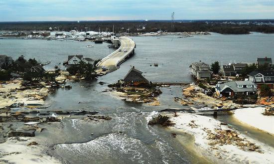
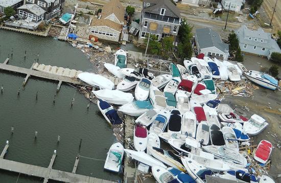
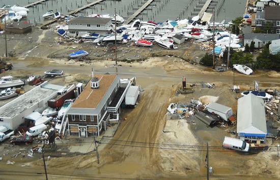
According to Dr. Stewart Farrell Director and Founder of the Coastal Research Center at Stockton University, when the ocean washed over Mantoloking, Bay Head, Ortley Beach and Holgate, “everything imaginable” was washed into the bay, ranging from entire houses, “white goods” (appliances), furniture, sporting equipment such as bicycles, golf clubs, and thousands of pavers.
“The pile of white goods I saw in Mantoloking was about 35 feet high. There were ranges, dryers, sinks, washing machines,” Farrell said.
“They also recovered boats in the woods that had come from the barrier island that were still attached to their trailers.”
The NJDEP, which was in charge of debris removal, hired private dredgers who were brought in to suck up all the material that had ended up in the bay, much of which could be seen at low tide when the debris was exposed, Farrell said.
The contractors emptied their dredge spoils into front end loaders and then into large sieves with rotating drums that separated the sand from the debris.
“The sand was put back on the land, and the big chunks, including many of the pavers, went elsewhere,” Farrell said.
Private contractors using side scan sonar scoured the bay floor, and divers hooked the large pieces of debris and pulled it up, he said.
“That last golf club isn’t coming back, and there are still thousands of pavers on the bay floor that are now part of the geographical record,” Farrell said.
The overwash created another problem, which was the damage to navigational channels due to shoaling from Sandy.
“FEMA said if you can prove what was deposited into the channels was from Sandy, we’ll pay 90 percent, but the problem was many of the 40 channels in Barnegat Bay had not been surveyed for over five years,” he said.
The Federal Emergency Management Agency said they would not pay for routine dredging of the channels, but they would pay for catastrophic dredging if it could be proven, Farrell recalled.
“Yours truly said that the sediment from Sandy would be different from the normal accrued sediment, so after vertical cores were sampled, and they looked at the material, FEMA agreed that it was not normal,” Farrell said.
Any contrast of the vertical cores, pre-and post-Sandy was “dramatically provable,” Farrell said. Therefore, the NJ Department of Transportation (DOT) “who is in charge of the marine highways,” hired 10 crews for every state channel. They dredged the channels from Raritan Bay to Cape May Point.
The telltale indicator of Sandy deposits was, in many places, about three feet of highly concentrated plant debris, such as seagrass and pine needles, over the original muddy sand bay floor, Farrell said.
Over the course of a year and a half, the NJDOT took 3,800 sample cores and photographs, and the results were turned over to FEMA for their review.
The Superstorm Sandy State Channels Dredging Project Worksheet has been approved by FEMA, at the cost of an estimated $61.5 million, covering 130 state navigation channels, said NJDOT Director of Communications Steve Schapiro.
He said the continuing NJDOT dredging to repair navigation channels due to Sandy would be paid for by NJDOT and would be eligible for 90 percent reimbursement by FEMA after the project completion.
“NJDOT will only receive reimbursement after projects are completed on a channel-by-channel basis,” Schapiro wrote in an email. “The cost of [dredging navigation channels in Barnegat Bay] is not a fixed number, and I don’t have any figures at this time,” he said.
deCamp of Save Barnegat Bay said that the bay has two big problems: a health problem and “an existential problem” in sea level rise.
“Society is in a strange state of awareness. They think that Sandy was an 800-year storm, and we don’t have to worry about it,” he said.
“But sea level rise could take away the barrier island,” deCamp said. “People don’t like to think about it or talk about it.”


